In early 2022, IGN FI won a contract with the Senegalese Air Force for visual flight mapping of the territory. For several decades, pilots in Senegal had been forced to fly with aeronautical charts dating back to the 1970s.
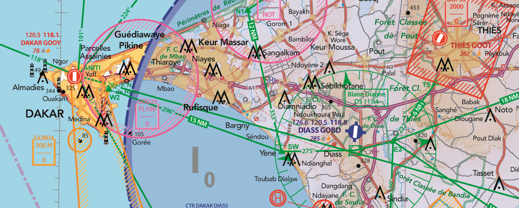
Cartographer Alain Rivas and project manager Auriane Sacoman, founder of the ‘Air Million’ aeronautical chart series, collaborated in 2022 to produce an updated visual flight chart for Senegal. At a scale of 1:500,000, the map is divided into two sheets, East and West, which cover the airspace of Senegal, Gambia, as well as a portion of the airspaces of Mauritania, Mali, Guinea-Bissau, and Guinea.
What is an aeronautical chart used for?
While large airliners or supersonic aircraft can, thanks to their instruments, fly very high, day and night, and in all weather conditions, smaller aircraft, however, can only fly during daylight hours, when meteorological conditions are favorable for visibility, and when the altitude allows them to maintain oxygen. The former are said to comply with Instrument Flight Rules (IFR, or Instrument Flight Rules), while the latter follow Visual Flight Rules (VFR, or Visual Flight Rules) based on the principle of “see and be seen, and avoid.” Consequently, aircraft flying visually need to orient themselves, establish a route, and maintain a course, all while ensuring they comply with the “rules of the air.”
The entire purpose of an aeronautical chart is to provide both topographical landmarks (terrain, urban areas, roads, railways, waterways, etc.) and aeronautical information (aerodromes, air corridors, obstacles, restricted areas, radio navigation aids, etc.). In other words, the aeronautical chart layers two types of information: a topographical base and an aeronautical overlay. This aeronautical overlay is a flat representation of a three-dimensional space, with air corridors defined laterally by geographical coordinate points and vertically by a flight floor and ceiling.
Six months after the project began, the VFR chart for Senegal was released in its v0 version.
The second phase of the project: training and equipment
A second phase of the project then began, which involves training a cartographic unit within the Air Force. In total, over ten months of training and twelve modules are to be provided: introduction to aeronautics, GIS, and cartography; photo-interpretation; geodesy and surveying; field data collection; photogrammetry; database management, etc. The objective is to train military personnel in modern cartography techniques while providing them with the means to update their VFR charts or create new ones fully adapted and customized to their requirements.
To this end, an entire room at the Ouakam air base in Dakar has been set up and equipped with computer workstations, small and large format printing equipment, a server, and appropriate software.
Thus, seven military personnel and one civilian will benefit from this very intensive and high-level training. “We welcome the excellent collaboration being established with the Air Force General Staff, with the support of project partners, AIBD SA (Aéroport Blaigne Diagne SA) and FATCO (Foreign Asset Trade Company) ,” says Christophe Grateau, Regional Director at IGN FI.